Agave Hill
Revised 20260115
31.913033° -106.506967° 5,335' MSL 600' AGL
LZ 31.910659° -106.519001°
Minimum Required Rating P3 (P2 if RGSA guide present)
Wind Strength (MPH)
Minimum 5, Ideal 10, Max 12, Gust 5
Launch Faces 260°
Synoptic Wind Direction (Degrees)
Ideal: Left 260 Right 280
OK: Left 220 Right 290
Minimum Required Glide Ratio: 5.5
When flown during thermic times/dates, TURB recommended
Site Protocols / Rules
All pilots must register with the Franklin Mountain State Park authorities before flying in the FMSP. Texas Parks and Wildlife requires current USHPA membership. Pilots are permitted to launch from and land anywhere within the boundaries of the FMSP, including paved roads. Visiting pilots must obtain an orientation from an experienced local pilot because of the sensitive relationship with the Franklin Mountains State Park. Contact the RGSA.
Do not forget to notify the Park before launching and after landing. Send a text message ONLY to (915) 539-0558 before launching and just after landing e.g. "John Doe launching from (site)" and "John Doe landed", respectively.
Key Site Safety Information:
There has only been one PG related injury at Agave Hill, due to a pilot attempting to launch in dead air and running nearly 200 feet down the hill before tripping and breaking an ankle. As long as the pilot aborts the takeoff by the end of the cleared area, Agave Hill is a forgiving launch and the closest thing we have to a "training hill" in the area. Training hill is in quites because this is still a desert mountain aite with rocks, cactus and the potential for being blown over the back if the winds aloft are strong. You will not enjoy flying the Franklins if winds aloft are faster than your glider's top speed.
General Info
Agave Hill is located within the Franklin Mountains State Park (FMSP) in El Paso, Texas and is the most frequently flown site within the Park.
This is both a ridge soaring and thermic site with lots of room for mistakes by newer pilots provided they launch within 2 hours of sunrise/sunset between March and October. November to February it is more feasible to fly mid-day, but caution must always be used; this is the desert and thermals can be sharp, strong and disorganized. It is an easy sled ride to the LZ with a glide ratio of about 5.5. There is almost no ridge lift at launch, the idea is to cross Deep Sink Canyon and make it over to the triangle, where the ridge lift is working. Low aspect ratio wings might require the use of the house thermal just north of launch to get high enough to cross Deep Sink. Higher aspect ratio wings can head directly across Deep Sink to the Triangle.
It is launchable with winds from 220° to 320°.
When winds are more southerly than 230°, ridge lift is poor and there can be some turbulence at launch.
It is also more difficult to cross Deep Sink Canyon due to the headwind. When winds go north of 290°, the site becomes more turbulent because of the small range in front, but it can still be flown if pilots are cautious about the crosswind from the right at launch. West or slightly north of west is ideal because then the wind is less oblique against the Triangle and it is easier to bench up. Thermals begin to fade 60-90
minutes
before sunset, but often the ridge lift is better and it is still possible to bench up. Winds can go to near zero at sunset and if this happens the katabatic (downhill) flow will start.
If conditions are weak and you are not content with a sledder and don't mind a longer hike, go to Nelson's Launch instead.
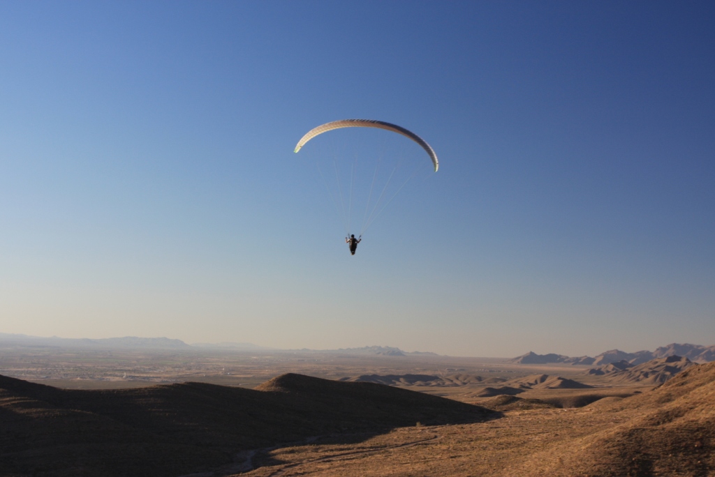
The Franklin Mountains present exciting
and challenging flying, especially for ridge and thermal soaring. Because of direct
exposure to the west and with no other mountain ranges out front, the range
has excellent soaring. On good days, an intermediate pilot can
fly more than 1,500' higher than the highest peak.
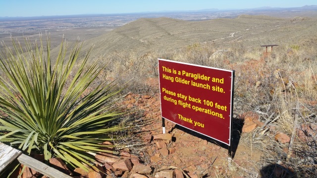
Photo by Steve Crye.
Directions to Agave Hill
Enter the Tom Mays Unit of Franklin Mountains State Park. The Park entrance is on the west side and right at the base of the Franklin Mountains off state route #375 (Transmountain Highway). Please call the Park at 915-444-9100 for current hours of operation and details on the fees. A map of Tom Mays is here. Locate the parking area (in the east part of the Park) that is for Agave Loop and the trails that go to Mundy's Gap and N. Mt. Franklin. It is a 10 to 45 minute hike to launch, depending on your condition and the weight of your kit. Google Earth Map of Agave Loop Trail.
Expectations for pilots new to Agave Hill
All pilots must be alert to:
1.) The presence of vehicles on the roads (our landing areas) and land in the desert next to the road if there are any vehicles nearby.
2.) The arroyos out front which must
be avoided because of the presence of rocks which can cause pilots to trip while landing. More advanced pilots can and have landed in the arroyos (not advised) but must avoid the rocks carefully. Other
than the few arroyos and the presence of vehicles there are hundreds of acres out front where a pilot can land – and walk out.
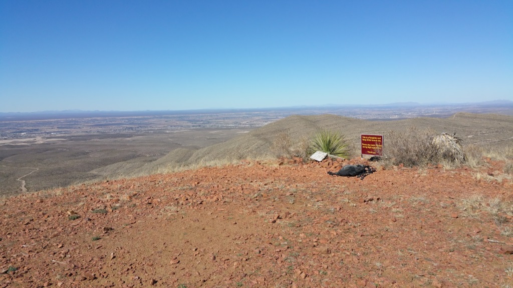
Photo by Steve Crye.
History
The sites within the Park were developed and first flown by Lee Boone and Had Robinson, except for Nelson's which was developed by Steve Crye, and North. Mt. Franklin, which was flown by hang glider pilots
decades ago. Robin Hastings was
the first hang glider pilot to fly Agave Hill. HG from Agave, although permitted, is impractible due to the length of the hike and the tall mesquite on each side of the entrance road (LZ)
Videos: Official Texas Parks & Wildlife paragliding at Agave Flying at Agave by Shelley
McKinlay. Many videos of Agave Hill on Steve Crye's YouTube Channel: Nelson's Wings
Lee Boone checking his glider before launching from Agave Hill..
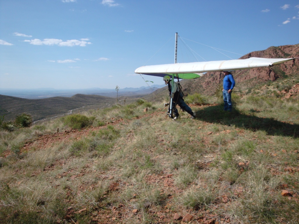
Robin Hastings launching his hang glider with help from Bill Cummings.
HG is no longer practical from Agave Hill.
Launching
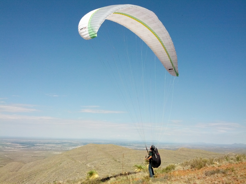
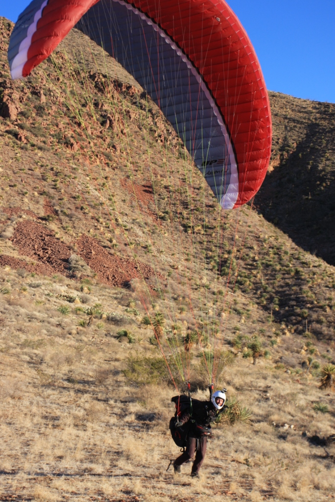
Agave Hill is an easy and forgiving launch. It is almost impossible to get blown over the back, even on strong days. It is a flat slope launch, so be prepared to run hard and skim the ground when conditions are light. When there is a north component to the wind, the wing will thrash around and weather-vane a bit while you get it stable.Pilots launching from Agave have the advantage of a shallow slope launch that is about 50 yards in length, a broad area behind launch that is safe and open in the case of some mishap while launching, and a large area to safely land out front. The site has no rotor or obstacles out front when the prevailing winds are in effect (240° - 280°). CAUTION: if you are not flying well, at least 5 feet off the ground when you cross the transition from the "grassy" slope to the native desert cactus and rocks farther down, ABORT! You do not want to be scraping and running down the rough slope. When in doubt, abort, walk up, and try again with a better run and more energy.
Until you have at least a half dozen flights from Agave, avoid launching in strong thermic conditions. Pilots are advised to stay to the left (south) as they head out and aim for the straight section of the access road west of the Park entrance shack. Setup is easy and forgiving as there is plenty of altitude to reach the road (the LZ). If pilots find themselves low after launch, stay out of the few gullies which are directly in front of launch and instead head for the higher parts of the slope out front or the jeep trail that goes just east of the access road before it turns northeast. Traffic is usually light on the entrance road, but if the pilot sees a vehicle coming, land in the bushes that are to the left of the road (south side). The downside is that glider lines will likely get caught and this will require some time to extract them.
Benching
Benching up at Agave can be challenging. Expect a sled ride, and be happy if you get up! Benching is not easily done on most days.
The Triangle
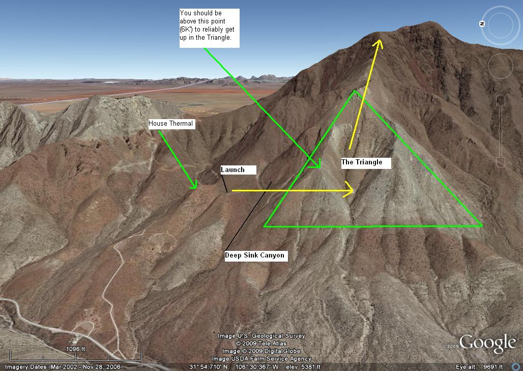
With a minimum of 100'
over launch, it is possible to fly south over Deep Sink Canyon and get to
The Triangle where there is real ridge lift. Steve Crye suggested this tip, "When crossing Deep Sink, especially when one has barely enough altitude, using 1/3 to 1/2 bar helps with the
crossing. Get off bar as soon as you are across." If you are patient and stay in this weak lift, an adequate thermal will drift and allow you to go right to the top
of the mountains (see the image below). It can be done!
The Triangle works with air the same way water runs down your arm and off your elbow. There are many ridges that go up from the base and connect at the top and so on. Thermals follow these ridges up and merge at the top. The very top of the Triangle has a sum of all the thermals going up the ridges. Thermals here have a period of about 4 minutes so you must be patient once you are aloft. Wind velocity periods are about 2+ minutes.
There are two general methods for getting to the triangle - heading over directly immediately after launch, or by turning to the right (north) after launch and working the house thermal until you are about 100' over launch, and then heading left (south). The method you choose will depend on several factors - your wing's performance, the direction and speed of the wind, the gusting, and the type of day (thermic or smooth) If turning right after launch, explore the house thermal and attempt to stay aloft. If the house thermal does not work, head for the road which goes to the parking lot for Mundy’s Gap. The road slopes down for ¼ mile and is very easy to land on. If there is a vehicle on the road simply land right next to the road on either side. As with nearly everywhere around
this launch site, there will be low bushes that will easily grab glider lines which must be carefully extracted.
If the winds are 230° to 250° benching is harder unless it is very strong/thermic, due to the wind hitting the Traiangle at an oblique angle. If the wind is 270° to 280° there will be minor rotor from the right edge of the launch hill and a tendency to be blown to the left; use caution with the knowlege that once you are flying it will be easier to get up. There are no cliffs or major
obstacles either in front or behind launch which means it's easy to bail in
case you need to.
When the winds are from 250° to 280° and flying a mid B wings and above head directly to the trangle after launch, and carefully work the lift there. CAUTION do not scratch too low in front of the Triangle - you could end up too low to make the road and experience an unpleasant ecounter with cactus.
The Triangle is bisected by two smaller triangles at the bottom. If you are near or above the top of the smaller triangle to the north, you will be at a sufficient altitude to bench up. In other words, if you are above launch and can look straight across to the top of this smaller triangle, head across Deep Sink Canyon. You may have to ridge soar the Triangle a while as you wait for a thermal to drift in from the valley. If winds are weak, be patient! If you do not know how to turn flat and conditions are weak, you will probably sink out. Who said this site is easy? However, if you bench up (like at Point of the Mountain), treasures await!
Stay away from the venturi at Mundy's Gap (the saddle northeast and behind launch). Do not fly behind launch unless you are certain the winds aloft (6K' MSL) are less than 15 mph (PG).
Pilot Lee Boone successfully benching up from launch in his UP Summit XC2.
Watch your forward speed at all times when getting high at the Triangle. If you think you are being blown backwards, apply full speed bar immediately and head straight out or south into the sinky area directly in front of N. Mount Franklin (between the ridges). You may have to juggle this maneuver with big ears. The gradients in the Franklins are substantial and going out and down will quickly get you out of the fast air. Lift is everywhere upwind of the range and you will find it a mile or more out in front 1+ hours either side of sunrise/sunset. It is not advisable to fly PG in the between the months of April and October between 1030 and 1730 – the thermals are very strong and turbulence near the terrain can be unnerving. Launching in the late afternoon increases the possibility of a smooth ride to the top. Stay within The Triangle as much as possible as there is bad sink/rotor in the canyons on either side. Once you are a few hundred feet above the top of The Triangle, you can drift back towards N. Mt. Franklin. If you find yourself going down, head back to The Triangle and try again. Be patient.
Make sure you have a vario with GPS and groundspeed functionality – you must always know your speed over the ground. At slow speeds you may be going forward or backward – make sure you know which. Altitude at launch is about the top of the morning inversion which covers the Rio Grande valley on some days and can make the air at launch variable until it breaks up. Pilots need to time their launch carefully at the beginning of a cycle if the winds are not strong enough to ridge-soar right off launch. If there is enough wind velocity to ridge soar at launch, the winds above launch could be dangerous and pilots might be blown back into Mundy's Gap. We do not recommend benching up if you must use speedbar to stay out in front. If winds are forecast >15 mph anywhere above 6400' MSL, it is best to stay on the ground and not risk being blown over the back
LZ
Top landing at Agave is possible, but rarely done.
The Park authorities have graciously permitted us to land anywhere in the Park, including on roads! A sled ride from launch will provide adequate altitude to
land just beyond (SW of) the entrance shack or, better, to land on the road
just southwest of the parking area at the base of the trail that goes to
Agave Hill. That way, you can hike back up to launch if you failed to
bench up the first time. It is advisable to put up a streamer on the
side of the road as wind direction can change often.
There is usually very little traffic on the access road which is our general LZ for all sites within the Park. When traffic is encountered, ALWAYS give them the right of way! However, drivers will typically wait until we clear the area – as here.
Landing on the main road
Gusting forecasts & Jet Stream Info
It is important to note that overhead disturbances, thermal activity, and the Jet Stream can greatly affect our flying in the Franklin mountains. Thermals and atmospheric disturbances can cause the Jet to mix down to the surface and cause dangerous shear turbulence. If you see any gusting in the hourly forecasts or the Jet is overhead, use extreme caution. It is possible to fly Agave on days with the Jet overhead, provided the winds at 8000' and below are less than 15 mph. Always be prepared for rock and roll.
Landing near or after sunset
If you land near or after sunset, be cautious of the katabatic flow that comes down the mountains. It can be just 20' thick, going west, and the air just above it can be moving east. Consequently, do NOT land near the mountains if it is late in the day but land on a high spot out a mile or more in front of the Park. While pilots can land safely anywhere in the flats in an emergency, it is best to stick to established roads, cleared areas, and trails. Be sure to personally check out the LZ's before using them. DO NOT WAIT UNTIL THE LAST MOMENT TO PICK OUT A SAFE LANDING AREA!Winds Aloft
Look at Windy.com, and XCskies if you have a subscription. If the forecast shows over 15 mph at 6400', do not fly as you can get blown over the top of the range which would not be fun ... The presence of the Triangle to the south of launch and the venturi at Mundy's Gap to the northeast always affect the winds at launch. Winds will always tend to be southwesterly regardless of whether winds aloft are much more west and even northwest. This is why it is important to have a visible windsock on the Park entrance road.
Remember: This is the desert and air during mid day, especially during the summer months, can be challenging. Less experienced pilots should stick to the early AM or late PM outside the late fall and winter months. Laminar air is almost always present late in the day and dreamboat soaring in the Franklins occurs at that time. Thermals can be gigantic and sharp-edged here, as in the Owens Valley. Always check the weather or with us before flying
Going over the Back
If you go over the back of the range, head northeast or you will fly into the controlled airspace ("C") of El Paso International Airport that begins at the north/south Patriot Freeway (Hwy 54). If you are being blown over the back by strong winds because you ignored all our warnings, get as high in lift as you can and then once you start descending again (after you are downwind of the range), turn downwind and fly at best glide (use your vario and know your wing to determine the ideal amount of bar or brake for the conditions). If you can, stay out of the controlled airspace. Land anywhere safe as far away as possible from the mountains. Do not land on Transmountain Road. Your ground crew or other pilots will call the airport if you must land in controlled airspace and notify them of the emergency so don't worry about that – just land safely. However, this event will never occur if you check winds aloft BEFORE flying!
Dragon's Mouth
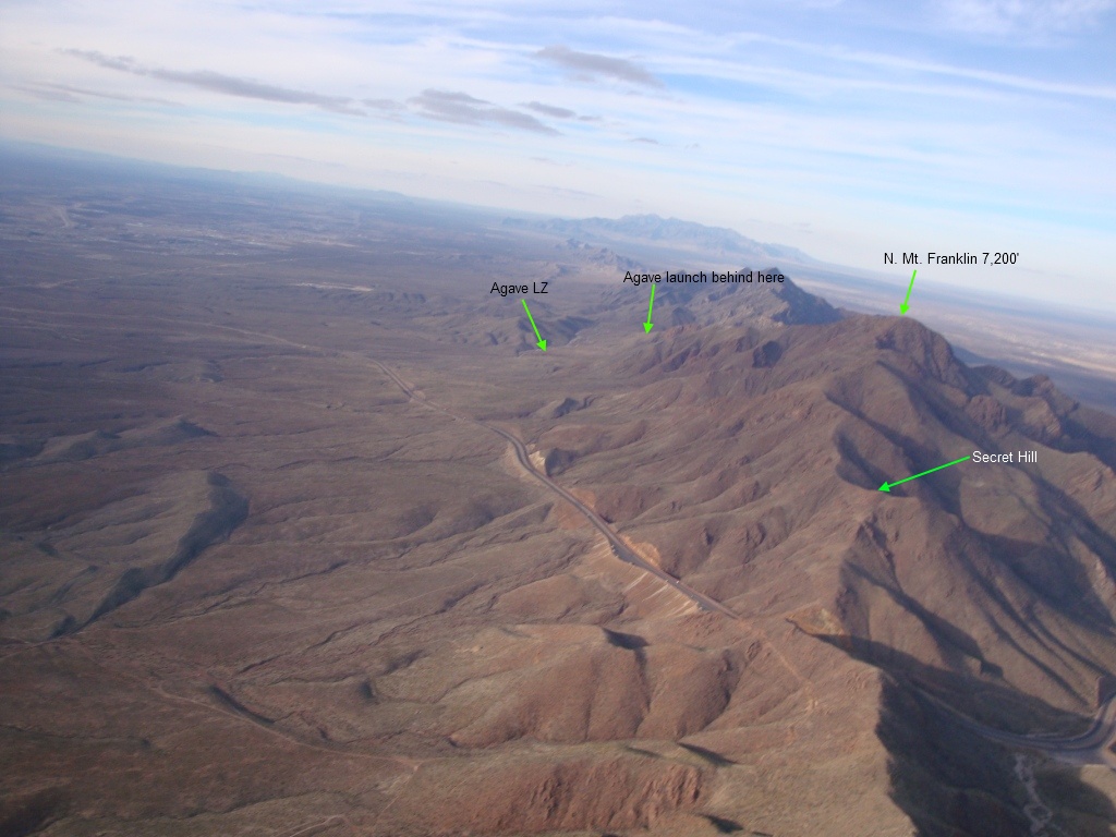
The Dragon's Mouth (DM) greatly affects the winds and lift in this part of the Franklins. When getting near or crossing Transmountain gap (State Hwy #375) from the south, it is important to be at 6800' MSL or above; if winds are >12 out in front, there is a risk of being sucked into the Pass – it is powerful venturi. When approaching the Pass from the north, the pilot will already be at 6800' or above. (Please see image below.)
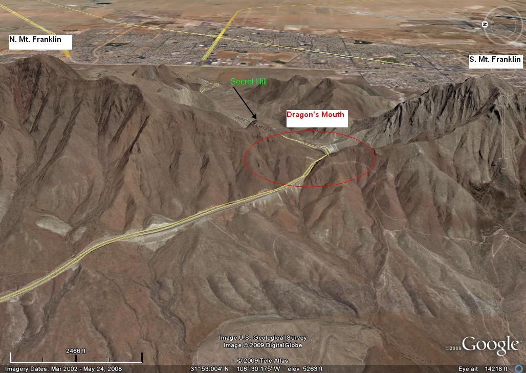
Crossing the Dragons' Mouth from south to north is more difficult. In the image above note the little hill just to the upper left of the red circle called Secret Hill. If you are coming from the south, you want to be sure your starting altitude is at least 6800' and then crab north directly over the ridge. If there are thermals look for obvious trigger points and use them.
If winds have any component greater than 280°, you will have to be higher in order to cross DM, because you will be going upwind. It is not recommended that pilots attempt to cross the DM from the south if winds are more northerly than 290° up to 10,000' MSL.
Stay west of the ridge by crabbing as you go north. As long as you can stay west of the ridge and move north, you will cross the gap. However, if you stop moving north it means that the wind velocity at the gap is the same as your forward speed! You can use some speed bar to continue but be careful. If you do not think you can reach Secret Hill, turn south immediately and land at the country club (easily visible with its fairways and greens). The DM is a giant sucking machine and gets worse the lower and east you go.Come down immediately and land anywhere if you start going backwards. Unlike flying through gradients, you will not easily know that your airspeed over the ground is decreasing. The change starts slowly and then increases rapidly as you get near DM. Mundy's Gap should also be avoided but is nothing like the Pass at Transmountain. Make sure your speed bar is attached and working properly before launching!! This is the most hazardous area of the Franklins but is easily avoided. If you can get to Secret Hill and be level with it, you are home free. Then, just follow the ridge right back up to the top of N. Mt. Franklin. The lift is superb north and above Secret Hill because it works much like the Triangle – thermals wick up the ridges and pop off the top of this hill. Always watch your ground speed carefully!
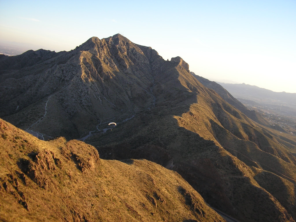 The view a pilot should have before crossing Transmountain heading south.
You will lose 500' to 1000' crossing the gap.The pilot under the white wing below is climbing up the southern spine of N. Mt. Franklin near Secret Hill.
The view a pilot should have before crossing Transmountain heading south.
You will lose 500' to 1000' crossing the gap.The pilot under the white wing below is climbing up the southern spine of N. Mt. Franklin near Secret Hill.
If you get sucked into the DM, don't panic – turn east, fly at min sink, and stay as high as you can.